Clifton Springs Fishing Structure Map

User avatar
Andrews
Rank: Premium Member
Joined: Mon Oct 07, 2019 2:41 pm
Location: Bellarine Peninsula
Has liked: 268 times
Likes received: 766 times

Clifton Springs Fishing Structure Map

Post by Andrews » Sun Jun 20, 2021 11:40 am

Hey everyone,

Inspired by Sebb's post of his success fishing Clifton Springs on the yak, I wanted to give a locals insight into the underrated gem that Clifton Springs and surrounds is for us land-based and yak fishers. As a young bloke who has lived in Clifton Springs for over ten years now, and most importantly has spearfished pretty much every inch of the Curlewis bank, I can provide some great insight into secret spots and potential this area has.

LANDSCAPE
Lets start with the landscape, this section of the Curlewis bank has a diverse range of structure and bottom types all at a very shallow depth.
Attached is a photo of the area with bottoms and structure circled.
Screenshot_5.jpg
HEAVY ROCK
This section circled in blue is the heaviest natural structure along this stretch of beach and begins at the first point on the left away from the boat ramp. The bottom structure is a mix of clay flats, shell grit sediment and medium sized rocks and iron rich rocks. This section is very shallow and is exposed on a low tide and often is piled up in decomposing eel grass. The mix of bottom structure makes this an awesome spot to chase flathead and their lies are often see silhouetted in the clay. I catch a lot of octopus by using a traditional Indigenous method, we use a reed or cane pole sharpened at the end of poke octopus holes until the octopus tries to escape the hole when it is the netted/released. The reason we use a reed/cane is because it is flexible and this to travel into the hole.

CLAY FLATS
These are one of the only naturally exposed clay flats on the Bellarine, and they are very impressive. The bottom is a mix of mud and clay and is incredibly slippery, you can find big chunks of white, yellow and red ochre washed up along the shoreline. This section is very shallow and a great spot to chase flathead, mullet and flounder.
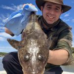
HEAVY SHELL GRIT

This point is where a lot of shell grit accumulates and it creates an amazing section of mud/sandy bottom with heavy grit, the perfect kgw spot. You can often see kgw cruising the shallows and if you were to wade out, you'd get them in 1-2m. Caught plenty here in summer while wading/spearing. Took this photo last month.
IMG_7856.jpg
HEAVY EEL GRASS
Since this whole area is really shallow, there isn't a huge amount of eel grass spread about. The thickest sections are by the boat ramp and the fishing pier (max 2m deep) is surrounded by thick eel grass. This makes for a great spot to chase calamari of a float (too shallow with jigs), mullet and garfish on a run out tide. There won't be heaps of gars but they will be big and a deeper colour green.

The second section is by the rockwall, there is a circle of heavy weed at around 2-3m deep which is killer for a floated jig or normal jigging. Get big squid here.

MUD SAND FLATS
This runs from the boat ramp edge all along to the Dell Reserve. This whole section is shallow, a matter of feet and can be very productive for kgw and flathead. The bottom is a mix of light rock, sand, mud and spots of shell grit. Photo attached. Good mix species.
clifton-springs-011.jpg
l-Rex-6968093-1.jpg
SPECIES
This area offers some amazing fishing potential and you can catch a diverse range of species here. Some I often see a lot of are flathead, calamari and kgw with your less desirables of mullet, wrasse and others being caught too.
Amateur Fisherman, South West Victoria / - Instagram:
https://www.instagram.com/fishingandrew/ Sponsors: Yamashita Australia, Sunline & Gomexus.

User avatar
Sebb
Rank: Premium Member
Joined: Mon Jun 13, 2016 3:30 pm
Has liked: 3010 times
Likes received: 1576 times

Re: Clifton Springs Fishing Structure Map

Post by Sebb » Sun Jun 20, 2021 12:15 pm

Great post and info! Thanks a lot, much appreciated. :tu:
Now I know there's a lot more to squid fishing there. This cut down the time needed to recon. :ch: cheers.
------------------------------
A fish is a fish :ft:
No fish is worth a life, stay safe

Lightningx
Bluefin
Bluefin
Joined: Wed Oct 01, 2014 4:21 pm
Has liked: 72 times
Likes received: 976 times

Re: Clifton Springs Fishing Structure Map

Post by Lightningx » Sun Jun 20, 2021 1:42 pm

Some great info there Andrews!
Thanks mate. Appreciate it.
Cheers 👍🏻

happyfriggincamper
Rank: Premium Member
Joined: Sat Oct 20, 2012 10:48 am
Has liked: 556 times
Likes received: 258 times

Re: Clifton Springs Fishing Structure Map

Post by happyfriggincamper » Sun Jun 20, 2021 7:26 pm

Really generous post and info there andrews - thanks for the detail and willingness to share.

Is it mostly low light times you have success there since it's so shallow or can you soak baits/cast plastics there and have success all day? And did you fish there LB just high tide or did you find you could get success on low as well?

jb2020
Rank: Baitfish
Rank: Baitfish
Joined: Fri May 24, 2013 3:12 pm

Re: Clifton Springs Fishing Structure Map

Post by jb2020 » Mon Jun 21, 2021 2:30 pm

Great post - Ive always said we should get half of melb to rape that spot whilst the other half is raping st leonards pier...

User avatar
Andrews
Rank: Premium Member
Joined: Mon Oct 07, 2019 2:41 pm
Location: Bellarine Peninsula
Has liked: 268 times
Likes received: 766 times

Re: Clifton Springs Fishing Structure Map

Post by Andrews » Tue Jun 22, 2021 10:32 am

Cheers Sebb, yeah there are some ripper spots down this way. The bank makes for some nice sandy/eel grass bottoms around that 2-3m mark.

No worries Lightningx!

Thanks Happyfriggincamper! I think the spot is all round successful, I have caught countless big flathead along the beaches and even in the boat ramp channel year round, different light conditions. The squid work best towards sunrise/sunset on ideally a high tide, they have been getting nice 40cm hoods off there in the past week. Not huge numbers, but bigger.

The tides work to your advantage, I think either run is good. If you want shallow, low tide lets you fish those deeper drop offs and normally unaccessable structure, while the high tide is good for pushing those deeper holes on the flats. Tide difference for the flats would be 30cm max.

If there is fish they will come, piers have been busy down this way with the garfish but looking at least week, one fish per 2 people was the success story haha.
Amateur Fisherman, South West Victoria / - Instagram:
https://www.instagram.com/fishingandrew/ Sponsors: Yamashita Australia, Sunline & Gomexus.

fishnut
Rank: Bream
Rank: Bream
Joined: Sat Sep 20, 2014 6:42 pm
Location: Altona meadows
Has liked: 28 times
Likes received: 219 times

Re: Clifton Springs Fishing Structure Map

Post by fishnut » Tue Jun 22, 2021 10:59 am

Great post Andrews very helpful

User avatar
Kimtown
Rank: Premium Member
Joined: Tue Jul 04, 2017 9:29 pm
Has liked: 303 times
Likes received: 310 times

Re: Clifton Springs Fishing Structure Map

Post by Kimtown » Tue Jun 22, 2021 1:44 pm

Awesome post Andrews, this is the type of info I use this site for, it’d be awesome to have something similar for the coronet bay or san remo area

Do you do much spearfishing outside of the bay? Ever try for crays or rock hop for Kings?

User avatar
Andrews
Rank: Premium Member
Joined: Mon Oct 07, 2019 2:41 pm
Location: Bellarine Peninsula
Has liked: 268 times
Likes received: 766 times

Re: Clifton Springs Fishing Structure Map

Post by Andrews » Tue Jun 22, 2021 4:36 pm

Thanks Fishnut!

Cheers Kimtown, yeah I wouldn't mind seeing something like this for the otherside, minaly because I've never fished the otherside of the bay and have never really seen the rocky outcrops, etc.

I can't say I have in a good while, few years back I'd go for crays with friends and the spearfishing more turned into me going for a swim and some dinner after work. Being so close to hope, ten minutes walk, five max on a bike, it was a great way to spend an evening haha.
Amateur Fisherman, South West Victoria / - Instagram:
https://www.instagram.com/fishingandrew/ Sponsors: Yamashita Australia, Sunline & Gomexus.

Seniorfisho
Rank: Snapper
Rank: Snapper
Joined: Tue Jan 14, 2020 1:32 pm
Has liked: 798 times
Likes received: 433 times

Re: Clifton Springs Fishing Structure Map

Post by Seniorfisho » Tue Jun 22, 2021 7:14 pm

That's some great info there Andrews, thanks for that. Do you know if you can launch a kayak down the bottom of McDermott rd?

Post Reply

Return to “Geelong, The Great Ocean Road and the Bellarine Peninsula Fishing Reports”